


Preview
Publisher
State of Western Australia
Document Type
Map
Creation Date
8-2014
Disciplines
Geographic Information Sciences | Physical and Environmental Geography
Description
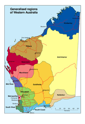
A map showing generalised geographic regions in Western Australia.
Recommended Citation
Department of Agriculture and Food, Western Australia.
(2014), Generalised Regions of Western Australia. State of Western Australia, Perth. Map.
https://library.dpird.wa.gov.au/gis_maps/11
Keywords
Western Australia, generalised geographic regions, Kimberley, Pilbara, Gascoyne, Murchison, Mid-West, Wheatbelt, Metropolitan, South West, South Coast, Goldfields, Nullarbor, Arid Interior

Comments
Notes on Generalised Regions of W.A. map
'Regions' has a different meaning depending on the Government Department.
This map is an attempt to produce a Regions map of Western Australia combining boundaries from a variety of sources:
Kimberley Region: Southern extent defined by the limit of pastoral leases, join with Pilbara Region is the southern boundary of Anna Plains pastoral lease.
Pilbara Region: Western extent defined by the limit of pastoral leases, southern boundary defined by the Gascoyne Catchment
Gascoyne Region: Based on the Gascoyne River Catchment boundary
Murchison Region: Based on the Murchison River Catchment boundary outside the limit of clearing.
Mid-West Region: Northern and Eastern boundary defined by the limit of clearing, southern boundary based on the Mid-West Regional Development Region boundary.
Wheatbelt Region: Based on the Wheatbelt Regional Development Region boundary.
Metropolitan Region: Based on the Dept. of Planning Metropolitan Region Scheme boundary.
South West: Based on the DAFWA South West Region boundary.
South Coast: Based on the DAFWA Southern Agricultural Region boundary up to the limit of clearing.
Goldfields: Eastern boundary defined by the limit of pastoral leases.
Nullarbor: Boundary defined by the limit of pastoral leases.
Arid Interior: Remaining part of the state where there are no pastoral leases.