

Preview
Document Type
Map
Creation Date
2016
Disciplines
Agriculture | Agronomy and Crop Sciences
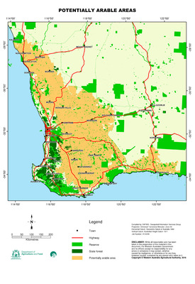
Description
The potentially arable areas dataset is derived from a number of source datasets to provide an approximation of the area of land in Western Australia which is potentially available for agricultural purposes.
The dataset was derived using the DAFWA Client-Property database, querying for agricultural properties, thus excluding any public land or land used for other purposes. This was then intersected with the Limit of Clearing dataset to exclude pastoral properties. Areas of native vegetation, old and new salinity and wetlands were then removed to give the resultant dataset.
A copy of the data set is available from the WA Shared Land Information Platform (SLIP) at data.wa.gov.au.
Recommended Citation
Geographic Information Services, D. (2016), Potentially arable areas in the Western Australian wheatbelt. Department of Primary Industries and Regional Development, Western Australia, Perth. Map.
Keywords
potentially arable land, cropping